Monday, October 2, 2023

Camel Valley Waterfall, Igatpuri, Kasara Ghat, Nashik, Maharashtra

Camel valley is situated at the top of Kasara Ghat near Igatpuri Hillstation. This valley is encountered when descending the Kasara ghat which is at the start point of the descent. There are small shops and parking area where there are lots and lots of monkeys. One can park the vehicle and can get into the valley to enjoy and relax the waterfalls as well as cherish the beautiful views. The camel valley can be a stop and go visit point. 

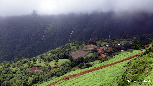
This was earlier used as a film shooting location for certain movies like Asoka. The valley is shaped such that during monsoon it will be covered throughout dense fog as the air funnels up the valley. Most of the time during monsoon months it is covered in dense fog and the views cannot be seen during monsoon. Hence best time to visit camel valley to see views is post monsoon whereas to enjoy the rain and fog, monsoon is best. Hence this is also known as fog city.

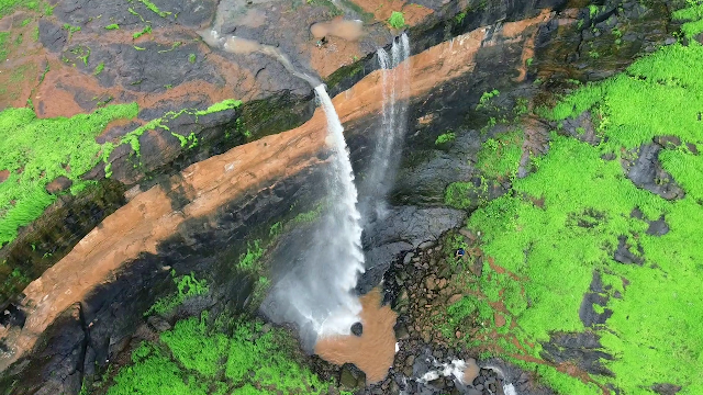
The waterfall which is located in this valley is multistage waterfall where it breaks into 3 stages from top to bottom which has an overall appx height of 1000feet or 300m. The longest drop is at first stage which is 100m and more. Camel valley waterfall receives its water from the nearby Talegaon mountains and flow all the way to join Bhatsa river which eventually drains into Bhatsa dam. There are many private hotels and resorts built above the waterfall. The waterfall is best viewed after monsoon due to low visibility in monsoon. There are small hills one can walk from parking lot to get the glimpse of waterfall from opposite hill. 

Camel Valley Waterfall, Igatpuri, Kasara Ghat, Nashik, Maharashtra

Camel Valley Waterfall, Igatpuri, Kasara Ghat, Nashik, Maharashtra
Kasara Ghat also known as Thal Ghat is a ghat section in the Western Ghats near the town of Kasara in Maharashtra. It is one of the 4 major ghats that joins Mumbai to deccan and lies on Mumbai Nashik route.
Camel Valley Waterfall, Igatpuri, Kasara Ghat, Nashik, Maharashtra

Camel Valley Waterfall, Igatpuri, Kasara Ghat, Nashik, Maharashtra
The 3 stages of Camel valley Waterfall as seen from opposite side of the waterfall hill.
Camel Valley Waterfall, Igatpuri, Kasara Ghat, Nashik, Maharashtra

Camel Valley Waterfall, Igatpuri, Kasara Ghat, Nashik, Maharashtra

Camel Valley Waterfall, Igatpuri, Kasara Ghat, Nashik, Maharashtra

Camel Valley Waterfall, Igatpuri, Kasara Ghat, Nashik, Maharashtra
Kasara Camel Valley mountains
Camel Valley Waterfall, Igatpuri, Kasara Ghat, Nashik, Maharashtra
Dense fog engulfs the whole valley with visibility barely few meters.
Camel Valley Waterfall, Igatpuri, Kasara Ghat, Nashik, Maharashtra
While climbing up the Kasara Ghat from Mumbai to Nashik side, on one side of the road is this unique style of enclosed well built by Ahilyabai Holkar. Earlier this well was a respite place for travelers going up and down the hill. It was built in such so that the evaporation is minimized unlike open wells. The well never dries up. Still now it is being used as a water source and some tankers come here to fill up the water. This is actually historic well. It is bound to be missed by most of the travelers as it is aside the road.


Sunday, September 24, 2023

Ashoka Waterfalls, Vihigaon, Kasara, Maharashtra

Ashoka waterfalls prior called Vihigaon falls is located in Kasara Budruk in Shahapur taluka of Thane district in Maharashtra. It is named Ashoka after the film Asoka which was filmed here as well as camel valley of Igatpuri a dance scene of San Sanana song. This waterfall is beautiful as huge volume of water flows through it during heavy rains. The water fall is easily accessible and there is ample of parking space at the top. Ashoka waterfall can be reached easily from either Nashik via Igatpuri or Mumbai.

Ashoka waterfall is actually quite beautiful to see when there is heavy rain. The pool of the waterfall is very safe and only waist deep for an average person. The waterfalls can be enjoyed even during moderate to high flow. Earlie the falls was accessible via rock trekking but nowadays it is renovated and stairs are made all the way down to the falls from the top parking area.

Ashoka waterfalls receives its water from the Kasara hills and eventually flows to the middle Vaitarna dam. A small dam is also constructed on the top where locals use the water regularly. Waterfall is well maintained and also publicly safe for all and family. There are eatery local stalls at top of the falls.

Also note some locals will randomly ask for money just for a sort of extra income.

HOW TO REACH

1) Take Kasara trains coming from CST station on Central Railway. Alight at Kasara then one can take share taxis to the Vihigaon Ashoka falls.

2) Once can drive their private vehicle till the falls. If coming from Mumbai side then one has to climb the Kasara ghat going to Nashik side up to a point where the road turns left towards Vihigaon side leaving the Kasara Ghat and passing through a small underpass. If one is coming from Nashik side, one has to descend the whole Kasara Ghat and then climb up again up to the point where road goes left towards Vihigaon

PARKING FEE: Rs 20/40 2wheeler/4wheeler and big buses have higher. 

However the locals are not much into it. they will have receipt but will not provide and say I don't know how to sign or write. So pay and take the receipt and write yourself the details or else the money will go straight to his pocket. Parking area is big but the roads are little offroad but manageable. 

ENTRY FEE: 30Rs / Person (They provide proper receipt)

CHANGING ROOMS: There are small washrooms but no water and also a changing room for ladies at the top in parking area.

TIMING OF ASHOKA FALLS: 9 Morning to 5 Evening

CLOSURE OF ASHOKA FALLS: Usually the falls are closed for 2 months July and August and then reopens on first week of September due to heavy rains. For people visiting on July and August, it is advised to confirm before visiting. From September its all open.

Ashoka Waterfalls, Vihigaon, Kasara, Maharashtra

Ashoka Waterfalls, Vihigaon, Kasara, Maharashtra

Ashoka Waterfalls, Vihigaon, Kasara, Maharashtra

Ashoka Waterfalls, Vihigaon, Kasara, Maharashtra

Ashoka Waterfalls, Vihigaon, Kasara, Maharashtra

Ashoka Waterfalls, Vihigaon, Kasara, Maharashtra

Ashoka Waterfalls, Vihigaon, Kasara, Maharashtra

Ashoka Waterfalls, Vihigaon, Kasara, Maharashtra

Ashoka Waterfalls, Vihigaon, Kasara, Maharashtra

ASHOKA WATERFALL VIDEO


Saturday, September 2, 2023

Madap Waterfalls, Chowk, Khalapur, Khopoli, Maharashtra

Madap waterfall lies in Chowk region of Khalapur in Khopoli of Maharashtra. Madap waterfalls is a beauty hidden inside the Madap hills close to Mumbai Pune expressway. Madap waterfalls is easily accessible which lies amidst a small mountain of Madap where a quite big village is situated at the top of Madap hill.

Madap Waterfalls, Chowk, Khalapur, Khopoli, Maharashtra

Madap waterfall has a height of around 40m appx. The water comes through various sources in Madap hills and falls into a quite wide pool full of rocks which are slippery. However the waterfall pool is just waist deep and quite safe to relax. But during heavy rains huge volume of waterflows through this and should not be crossed or swim under. Also the water falls through an overhang rock cliff with less space behind the falls. There is no route to top from besides the falls as the cliffs are very steep and slippery. Also there is another waterfall nearby with no pool but good for rappelling.

Madap Waterfalls, Chowk, Khalapur, Khopoli, Maharashtra

Madap Waterfalls, Chowk, Khalapur, Khopoli, Maharashtra

Madap Waterfalls, Chowk, Khalapur, Khopoli, Maharashtra

Madap Waterfalls, Chowk, Khalapur, Khopoli, Maharashtra

Madap Waterfalls, Chowk, Khalapur, Khopoli, Maharashtra

Madap Waterfalls, Chowk, Khalapur, Khopoli, Maharashtra

Madap Waterfalls, Chowk, Khalapur, Khopoli, Maharashtra

HOW TO REACH MADAP WATERFALL:

There are two ways to reach Madap waterfall.

As shown in the map below there are Route 1 and Route 2. However one has to first reach express city near Madap. (building project). From Mumbai head for Chowk village and proceed. From Pune either from Khopoli or Khalapur one can head to express city and Madap.

Route 1:

From route one there is motorable road till the river crossing point. But this road is very rough and narrow for barely one car. No problem for bikes though. You can drive till the crossing point and park there after which you have to cross the river on foot and go till the second small bridge. Not much parking space is available for 4 wheeler but ample space for 2 wheeler. This route further goes up the top of hill to Madap village. From crossing point it is a km walk till the falls. However the river crossing is very slippery and when flow of water is high it should not be crossed and route 2 should be used. For 4 wheeler best option is to park at the Express city main road and walk upto this point or take route 2 if no crossing is needed. 

Route 2:

Route 2 goes further into the city and then from there you can enter rice fields to walk upto the small bridge which joins with route 1 and walk till the falls. Good thing about this route is the river needs not be crossed.

Route 1 and Route 2 eventually meets at the small bridge point after which it passes aside paddy fields and then a second river crossing point where an upstream short trek to the falls needs to be done. However if it rains heavy the upstream part should not be done as volume of the flow is very high. One can be swept away or get locked inbetween. 

Google Map Link

MADAP WATERFALL MAP ROUTE


Sunday, August 6, 2023

Sonara Waterfall, Vitthalgaon, Shahapur, Maharashtra

Sonara waterfall is a beautiful waterfall with its unique fall structure from an overhang. However to reach the waterfall, ones vehicle needs to be in good condition as it is inside remote from Shahapur in Thane.

Sonara Waterfall, Vitthalgaon, Shahapur, Maharashtra

How to reach Sonara Waterfall:

To reach Sonara waterfall one can go either from Murbad or from Shahapur. Murbad route is 5km longer. However the road conditions to Shendrun village which is at the highway from both the big cities are bad at the intervals. Road is very wide though. Recommended route is via Shahapur. From Shendrun village the road is good till Alyani village as shown down in the map. From Alyani as you enter Vitthalgaon village the road narrows to a single car lane with lot of potholes and roughness. However for 2 wheelers there is no problem but for 4 wheeler it will be difficult to maneuver. If two vehicles come face to face there is no chance. Avoid taking 4 wheelers to visit this falls or park somewhere near Alyani, but gist is avoid 4 wheelers. SUV's Jeep is a big no here as the roads are not wide that enough. 

As shown in the map where the road ends, from there it is a simple 15mins walk to falls which is visible from road too. Not much of a hike. 

Waterfall is very safe and easy to reach, however the rocks are slippery. The pool is small with a single protruding rock in middle. One can easily reach the top of waterfall and enjoy there which also provides good views of the surrounding. It is a simple and enjoyable waterfall but the road conditions for vehicle to go there is rough and very narrow from Vitthalgaon. No issue for 2 wheelers.

Sonara Waterfall Map


Saturday, August 5, 2023

Subhedar Waterfall, Uchale, Siddhagad, Murbad, Maharashtra

Subhedar Waterfall is located at the on route to Siddhagad fort. The route is fairly simple and easy to reach. The waterfall is big and very beautifully located inside the dense forests of Bhimashankar. The waterfall is known as Subhedar Falls. However there is one more in Karjat but it is a different and smaller one.

This waterfalls comes a little detour on the Siddhagad fort trekking route. Two wheelers can go upto a small village further inside (Rs20 parking) the main Uchale village which is on the main road. However 4 wheelers need to be parked at the main road or little inside (no charge). It takes around 30 to 40 mins walk from the Uchale village main road till the Subhedar waterfalls. 

There are multiple ways to reach Subhedar, either from Narivali or from Uchale village. The route from Uchale village is shorter and more distinct. One can also see the Siddhagad, Gorakhgad and Ahupe ghat enroute. The walk is straight upto the Dhapadpada a small village after which there is a short 5 mins climb upto the plateau till the hut as shown in video. From the hut straight goes to the fort and a slight right goes to the falls. The Subhedar falls is visible from the village itself.

Subhedar Waterfall, Uchale, Siddhagad, Murbad, Maharashtra

Subhedar Waterfall, Uchale, Siddhagad, Murbad, Maharashtra

Subhedar Waterfall, Uchale, Siddhagad, Murbad, Maharashtra

Subhedar Waterfall, Uchale, Siddhagad, Murbad, Maharashtra

Subhedar Waterfall, Uchale, Siddhagad, Murbad, Maharashtra

Subhedar Waterfall, Uchale, Siddhagad, Murbad, Maharashtra

Uchale village is on the main road where ST bus and tumtums also arrives. There is a famous vadapav right at the entrance. Tuljha Bhavani vada pav center. He gives one of the tastiest vada pav along with his specially made chutney. One can also place order for home cooked non veg foods. His dishes are very spicy (zhanzhanit). If you want less please tell him before.The route goes right aside this vadapav center to the falls.

The waterfall is safe but during heavy rains the level of the water rises quickly. Also there is a small pond nearby the falls where local children jump to swim. However the pond is deep and should not be explored by non swimmers.

The local villagers are very friendly and they will guide you if you are facing any problem. The Tuljabhavani vada pav person is also very helpful and guide you. 

His name is Bharat Bhoir - 9011160519 / 9527268355 

Subhedar Waterfall Map Location


Thursday, June 15, 2023

Garbett Plateau Trek, Neral, Matheran

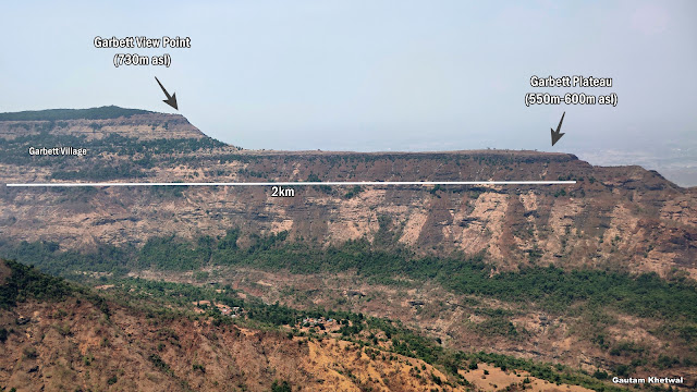
Garbett Plateau is a vast plateau which is elongated in shape. This plateau is very long and distinct. It can be seen from anywhere from Matheran view points. This plateau has one village amidst the jungles. From this village people come up to Matheran to do business. Garbett has a view point upto which it can be hiked or trekked. From the Garbett view point one can see whole of Garbett plateau till the end.

There are 2 ways to reach the Garbett plateau

1) Either from Matheran (Dasturi Naka) which is a hike walk amidst the jungles. (SHORT WAY) 2.5-3km

2) Trek from Diksal village which is at the base (LONG WAY) 9km

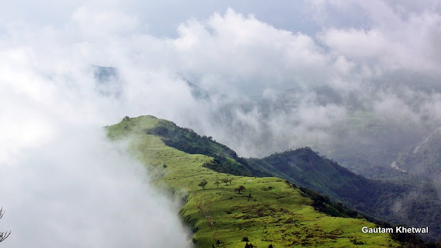
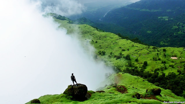
Garbett plateau is known for its green pastures and unique beauty in which it is mostly covered in clouds during monsoon. One side is full of clouds and other side is full clean especially a phenomenon seen during monsoon season.

One can also see many waterfalls, lakes, pastures and dam along the way to Garbett plateau. Garbett plateau overall length is around 2km long and around 50m and its thinnest width. Garbett Plateau elevation is around 550m to 600m above sea level whereas its Garbett viewpoint which is at top is around 730m above sea level.

Garbett Plateau Trek, Neral, Matheran

How to reach Garbett Plateau?

ROUTE 1: HIKE from Dasturi naka in Matheran

There is a route which goes to Garbett Plateau view point from Matheran. There are well marked boards to Garbett point. Usually horses do not go to this point as at places the route is washed and narrow. This is more sort of a hike or walk amidst the jungles. This point is best when walked. Most of the people take this route as it does not involve trekking. It is a straightforward route to the view point and takes less time. It is around 2.5km oneway walk from the Matheran rail tracks to the point.

This walk is the most beautiful in Matheran as it is untouched and the jungles are calm serene with winds blowing by. Mist all over the forest and dense jungles are beautiful here.

Garbett Plateau Trek, Neral, Matheran

The point area above is quite big but since it is occupied and climbed by only trekkers you wont find any refreshment stalls here. This is the beauty of this point. The point offers all 270 view of Garbett Plateau. The point is barricaded like other Matheran points and safety is there.

Garbett Plateau Trek, Neral, Matheran

Garbett Plateau Trek, Neral, Matheran

Garbett Plateau village was once a British village with and the plateau was famous for the quartz crystal which was found abundant and scattered all over the plateau. Now it is a vast grazing pastures for the animals cattles and goats. Another route goes down from the Garbett plateau to a village called Sagachiwadi which is the second base village of Garbett while climbing from Diksal village.

Garbett Plateau Trek, Neral, Matheran
Cattles grazing on Garbett Plateau
Garbett Plateau Trek, Neral, Matheran
Staring at the sea of clouds from Garbett Plateau
Garbett Plateau Trek, Neral, Matheran
Climbing up to the Garbett Point from Garbett Plateau
Garbett Plateau Trek, Neral, Matheran
Climbing up to the Garbett Point from Garbett Plateau
Garbett Plateau Trek, Neral, Matheran

Garbett Plateau Trek, Neral, Matheran

ROUTE 2: Trek from Diksal Village via Sagachiwadi village and Dhom dam

The full trek from the base Diksal (konkan) till the top is very long and quite an endurance is required.

The total distance of the trek from the base of mountain Diksal is as follows:

1) Diksal village to Garbett Plateau entry - 4.5km

2) Garbett Plateau Entry to Garbett view point - 2km

3) Garbett view point to Matheran tracks - 2.5km

It takes a trek of total 9km right from Diksal village, Neral to Matheran


The route starts from Diksal village. The route shown in above map is the most common one which almost every trekker takes. However there are multiple ways to reach Sagachiwadi as well as there are multiple ways to reach the spur walk from Sagachiwadi as the area is wide open.
The trek route is pretty straightforward. One has to just keep climbing and walking for a total of 9km to reach Matheran tracks or 6.5km till the Garbett view point. It takes quite an endurance and time around 3 to 4 hours casually.

Garbett Plateau Trek, Neral, Matheran

Garbett Plateau Trek, Neral, Matheran

Garbett Plateau Trek, Neral, Matheran

Garbett Plateau Trek, Neral, Matheran

The view from Garbett plateau is excellent and picturesque. Though being close to Matheran Garbett plateau seems out like it is from a different world with utmost peace and tranquil.

Garbett was usually called as Gharbut as its name is local. Gars means quartz in marathi hence this plateau was abundant in Quartz or Gars getting its name as Garbut or later Garbett Plateau. The uniqueness is that there is only one side of the valley densly covered in fog whereas the other side of the valley remains clean most of the time giving it a distinct feature in monsoon.

Garbett Plateau Trek, Neral, Matheran

Garbett Plateau Trek, Neral, Matheran

Garbett village is a group of villages which is away from market and situated on the valley shadow of Garbett hill. The village has rock cuts steps to go down which is mostly weathered out and used by the locals to come up to Matheran to do business. The village is unique as it stands since ancient times.

Garbett Plateau Trek, Neral, Matheran
This Garbett village is no less than a village from swiss alps. The location of the village is very beautiful.
Garbett Plateau Trek, Neral, Matheran

Garbett Plateau Trek, Neral, Matheran

Garbett Plateau Trek, Neral, Matheran


One can even enjoy DIKSAL WATERFALL enroute