Wednesday, October 12, 2016

Kalavantin Durg, Prabalgad, Panvel

Prabalgad and Kalavantin Durg are two separate hills close to each other. Prabalgad is more of a plateau type (table mountain) while Kalavantin is a steep eroded hill with not much area at top.
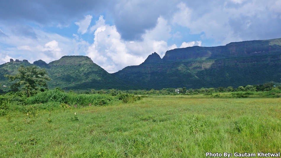
On the left the pointed part is the Kalavantin while on the right the table land is Prabalgad. Base village of Prabalgad is Thakurwadi which is accessible and any rickshaw can take one there from Panvel. From Thakurwadi climb starts with wide rocky road till second base village Prabalmachi. 
There are two steps one being Prabalmachi and other being the top part of the Forts.
Prabalmachi being at around 450m above sea level and Prabalgad top is around 750m above sea level.
Small village is set in Prabalmachi where villagers provide food and accomodation on request.
Also at certain spots in climb small tents are setup by villagers to provide refreshments.
Trekking till Prabalmachi is very easy and like a leisure walk till village.
Real trek starts from the Prabalmachi to Kalavantin or Prabalgad.
One can trek both hills on single day provided one has enough endurance to withstand the terrain else only one climb in a day is possible.
One can see the Prabalmachi the first step on the above photo where base is far behind. Farming is main occupation on Prabalmachi.
Kalavantin's beauty lies in its structure and its steps. The steps are very steep and has irregular heights. The steps become very slippery during rains and avoid this durg during rains as waterfalls on this step. Kalavantin is named after a queen and the steps are said to be from the times of Buddha. Kalavantin steps are till top after which just 15 mins steep rock climb will take you till top. Kalavantin acted as a watch tower during early days to keep an eye on other forts. This provides a 360 degree view of all the forts in the region seen below.
Every fort can be seen from this point like Malangad, Chanderi, Soneri, Mhasmal, Nakhind, Vikatgad, Karnala, Matheran, Tavli.
There are small caves in Kalavantin adn Prabalgad. Prabalgad has two view points. North end and South end. North end is Kalavantin view point which is 10mins from Prabalgad junction while the South end is far deep inside the dense jungle called Kala Buruj from where Irshalgad, Morbe dam, Manikgad can be seen. One need a whole day to visit Prabalgad.
Mountain view from Prabalgad. Climbing Prabalgad or Kalavantin is easy but very exhaustive. If one suffers from phobia of heights or vertigo Kalavantin is highly not recommended.
Parking for vehicles is available at the base. 


Thursday, August 25, 2016

Bhivpuri Waterfalls, Karjat

Bhivpuri waterfalls is located in Karjat region of Maharashtra. Bhivpuri waterfall is one of the high waterfalls in Karjat. It gets its water from the Bhivpuri hills at the base of the Matheran hills. Bhiv puri waterfall pool depth is waist deep and can rise up during heavy rainfall. It resembles same as Pandavkada waterfall of Kharghar. The height of waterfall is appx 60+ meters. It is a multistage waterfall. Bhivpuri waterfalls are also called Ashane waterfall named after the village Ashane. Also there is one more waterfall close to it called Bekare waterfall in which rappelling can also be done and it resembles like Vihigaon waterfall in Kasara. 
 BHIVPURI WATERFALLS, KARJAT
There is a village located at top of these falls which is accessible and one has to climb the ridge all the way till top from base of Bhivpuri village. One can also climb from the waterfall side route but that is too steep and slippery during rains. The waterfall is not pure in terms of getting drenched below since there is habitation above the falls. Bhivpuri has many waterfalls this being the center of attraction.
In above photo one can see Matheran far beyond and Bhivpuri hills in front of it. One can say there is a tableland like feature on top of Bhivpuri hills. Vast verdant meadows with animals grazing around.
In above picture one can see vast stretches of flat tableland on top of Bhivpuri hills.
 Too much crowd during holidays.

Bhivpuri hills are famous for picnic makers. However it is extremely crowded during holidays just like our mumbai local trains. There are numerous stalls setup by villagers along the way. They sell all items from food till beer. Due to heavy crowd the waste accumulated is too much at the base of waterfalls. Also heavy consumption of alcohol is done by the public during holidays. Bottles and crushed glasses, plastics lying everywhere. Advise not to throw waste in falls. If one wants to enjoy the serenity of the falls not recommended to go during holidays. 


Key Points:

1) Waterfalls are not dangerous but during heavy rains it roars.
2) Easily accessible from main road (walking distance). Rail station: Bhivpuri Road.
3) One can take private cars but the villagers take a lot of price for parking ranging from 50 to 100 or even more and without receipt. Also they charge for visiting waterfall somewhere around 10, a cheap way of making money from visitors.
4) If do not want to encounter crowd go early in morning before 10:00 AM.
5) One can also visit the Dhom dam close by the falls.
6) No alcohols please.
7) PLEASE DO NOT LEAVE ANY WASTE BEHIND. KEEP ENVIRONMENT CLEAN.

Thursday, July 28, 2016

Tapalwadi Anandwadi Waterfalls, Neral

Tapalwadi and Anandwadi Waterfalls are sister waterfalls situated closely. These waterfalls are safe and not dangerous as the pool depth is waist deep but the force of water falling is great. These two waterfalls are situated at the base of Peb Fort hill. One can visit these waterfall while climbing Peb fort. The appx height of these waterfalls may be 90 feet. Since these waterfalls are situated at the base of Peb hill, during heavy rains the water can turn muddy with rocks falling from above suddenly.
The force of water and pool depth is more in Anandwadi waterfall than Tapalwadi waterfall. Anandwadi waterfall is more beautiful than Tapalwadi waterfall. Tapalwadi is easily accessible from Tapalwadi village. Do not throw wastes in the river, it harms the environment.


KEEP NATURE CLEAN AND GREEN

Tuesday, July 12, 2016

Chinchoti Waterfalls, Vasai

Chinchoti is a village in Kaman region of Vasai. The waterfall is named after it as Chinchoti is the base village for the waterfall. One has to walk 30 to 45 mins at a good pace to reach Chinchoti waterfall. It is a sort of trek but not a trek. The route is easy and straight forward. Walking distance to this waterfall is about 3 kms from base village with an altitude climb of 320 meters above sea level. 
Chinchoti waterfall can be dangerous when high volume of water flows in it during heavy rainfall. A huge rock can be seen on top of this waterfall.
At base there are numerous small pools of water. The place where water falls is deep and dangerous.
The river bed is very rocky and can be very deep at certain places. The depths are deceiving.
One can reach top of waterfall by climbing a steep hill on its side. 
Chinchoti waterfall has two stages. One shown above is a stage one where many people come to visit.
Stage two waterfall needs to be trekked inside the jungle.
The picture shown above is of a stage two Chinchoti waterfall. Few people come here as this is a dangerous spot to be. Since this waterfall has a great height more than 100 feet the water has great power. The rocks are huge and tremendous amount of water flows through it. There are many small waterfalls in this jungles.
Chinchoti waterfalls are great place for adventure, trekkers, nature lovers. 


Key Points:

1) Waterfall is dangerous. Rocks are slippery.
2) Jungles are dense, explore only if in groups.
3) River bed depth is unpredictable.
4) Lot of wastes during sunday crowd.
5) Parking available at base but road is narrow and base is too muddy for small cars. Might get stuck. Fine for bikes.

Many people come here during picnic and leave much wastes behind. Please pick up the wastes. It destroys Nature.
KEEP NATURE CLEAN