Wednesday, February 27, 2019

Sindola/Shindola Fort Trek, Karanjale, Malshej Ghat, Maharashtra

Sindola or Shindola fort is a small hill fort in Junnar region of Maharashtra on top of Malshej Ghat Plateau. Sindola mountain is distinct by its pinnacle structure visible from anywhere. Sindola is more of a sort of military base as it offers whole view of Malshej and Pargaon region and all of its neighboring forts. Sindola dates back very old at the similar times of Nimgiri and Hadsar.

The start of Sindola fort is from Karanjale village which is one of the 3 base villages of Sindola. Other being Bagadwadi at Pargaon and other Velkhind which connects Malshej to Pargaon region. The route starts from the fields opposite the signboard of Karanjale village from the fields. The route is not marked but is quite distinct as one has to go up and reach Sindola plateau at the start point of the ridge. Route is quite distinct and less chance of losing the way.
Climb to the ridge can be started from any side but one will have to go through dense bushes. The easiest way to climb is to head for the start of the ridge which has no dense bushes. One can see whole neighbouring region of Sindola while climbing the ridge.


After climbing the ridge one will reach the spot of Sindola pinnacle. After this the route traverses towards the left side and reaches a gully from where one has to climb up through rock cut steps at certain intervals.


 Pimpalgaon Jog Dam can be seen clearly.
 There are 7 water cisterns carved into the rock.
 MTDC resort of Malshej can be seen clearly from Sindola.


 Bhairavnath mandir as seen in opposite mountain of Sindola on Udhalya hill.
 North Panoramic View from Sindola Fort
South Panoramic View from Sindola Fort

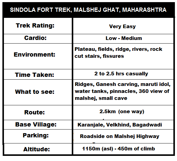
Route to Sindola is pretty straight forward, easy to moderate climb (monsoon) and requires 2.5 km trek with an altitude gain of appx 450m where as overall height of mountain is around 1150m asl.
Sindola Fort Trek Map Route


Summary

Wednesday, February 6, 2019

Durg Bhandar Fort Trek, Brahmagiri, Trimbakeshwar, Nasik

Durg Bhandar lies in Nashik region near in Trimbakeshwar and part of Brahmagiri mountain. Durg Bhandar or Bhandar Durg is more sort of a watchtower. The main attraction here is the deep rock cut steps which goes deep inside from Brahmagiri mountain the fissure and comes out in natural bridge and again goes up the fissure to Durg Bhandar. Apart from this Brahmagiri is also the source of Godavari river which flows towards east and meets Bay of Bengal. Durg Bhandar has a unique shape as it is like a cubicle and seperated from main mountain by the natural rock bridge.
Reaching Durg Bhandar is very easy and one has to first go Brahmagiri then from there the route starts to Durg Bhandar from Shiv Jata Temple. While climbing one can experience the beauty of such structure as well as the history of such a place.

While climbing one is able to see all historic structures, carved idols, caves, steps, temples. The route is very easy, safe with railings provided and refreshments all the way. The climb to Brahmagiri is through rock cut steps which is amazing and beautiful with two entrance gates beautifully carved and big hanuman idol carved in the rock.

 Hanuman Idol carved in rock (on the way)
 Small caves with beautiful rock cut idols
Entrance gates beautifully carved
After climbing the steps, one reaches the top plateau which is very vast. The Brahmagiri plateau has various view points and temples, a lake and some ruins. The plateau is very beautiful and is a gateway to Durg Bhandar. The plateau is safe to visit as railings are provided.
 One can see Harihar, Brahma Parvat and many other mountains from Brahmagiri.
 Durg Bhandar at far end and Brahmagiri Plateau.
Brahmagiri is a short trek but requires more steps to climb. However a fit person can do it easily where as aged people will require more time. As many people come here to perform pooja at Godavari main source where there is temple, all age of people climb up.
Way to Durg Bhandar starts from a temple of Shiv Jata where the route passes through the west side of mountain. the trail is easy and well defined. It takes straight towards the rock fissure where the steps are carved.
 Shiv Jata Mandir (Start point of Durg Bhandar)
Durg Bhandar as seen from top, shape of a cuboid type with a depression of rock bridge connecting Brahmagiri to Durg.

Start of fissure with rock cut steps going down till the rock bridge. The fissure is around 100 feet deep and is marvelously made. The steps or the fissure is made in such a way that it cannot be seen from anywhere from base and is visible only when one comes near it. A perfect and smart way to camouflage and hide from enemy. No wonder it was such a strong watchtower.
 Steps go deep on both the sides of fissure.
 The rock bridge is amazing and narrow. One has to be careful on the bridge. It is quite wide to see though but still the drops on the sides are very steep.
 Fissure opening on Durg Bhandar side.
On the end of Durg Bhandar there is a bastion which is quite small and was used to guard or keep an eye over the region. Perfect place for Kadelot.
The mountain and fort is very sacred as it lies in Trimbakeshwar and is source of Sahyadri. It is surrounded by small houses and towns of Trimbakeshwar. One can also stay at MTDC which is the start point of the climb.
One can also visit various temples in Trimbakeshwar or at the top of Brahmagiri mountain as the place is bustling with numerous temples. Gangadwar, Gorakshnath Cave lies at the base of Durg Bhandar where as the main source of temple lies at the Brahmagiri plateau.

Durg Bhandar Fort Trek Route Map