Bhairavgad lies in Thane region of Maharashtra and is actually not a fort but a rock dike structure which is very rare in Sahyadris, other being Tailbaila. Other Bhairavgad is at Chiplun, Bhandardara. And this one is at Moroshi or Moroshi che Bhairavgad. This is a distinct rockface which is easily visible from state highway towards Malshej. Bhairavgad seems impossible to climb due to its steep rock rectangular face. But there are rock cut steps till top which are blown away by Britishers making it difficult to ascend. Bhairavgad appx height is around 700m above sea level. Bhairavmachi is appx 580m. There is a kaman which is rusted through which one can reach Bhairavmachi. It stands separated from the main ghats. Bhairavgad offers great view of all the surrounding ghats.
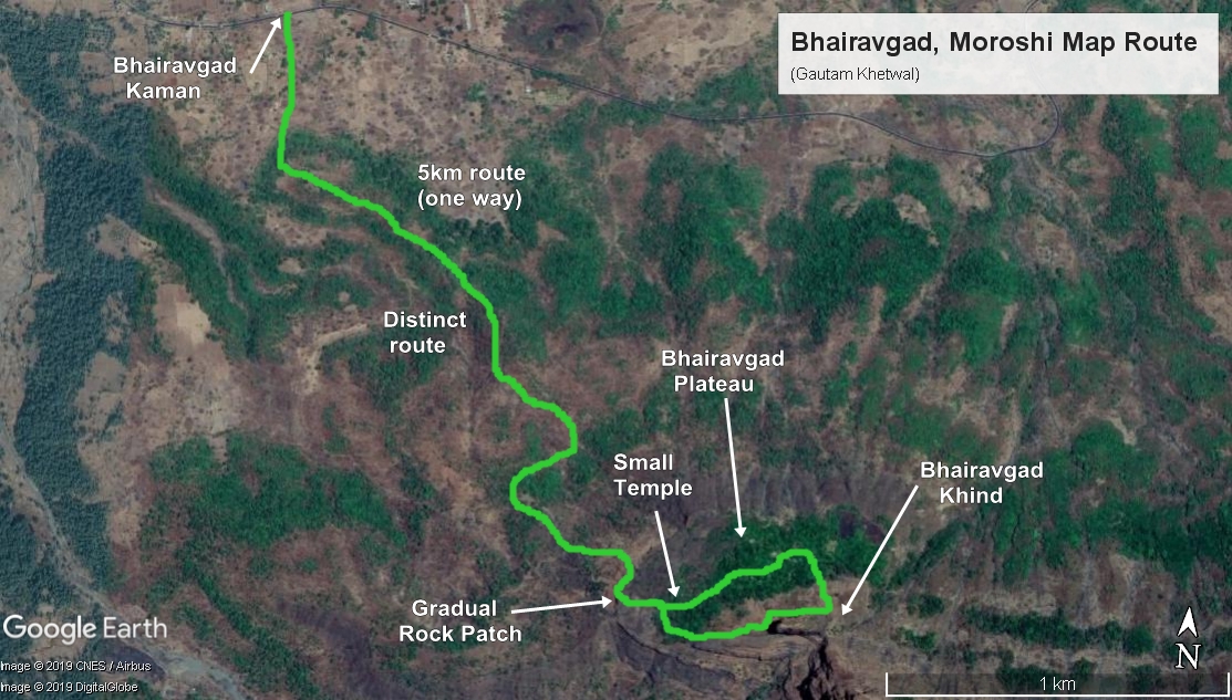
There are several criss cross routes to Bhairavmachi which is confusing but just keep following the broadest one and you will reach Bhairavmachi. From Bhairavmachi one has to go inside the forest to reach the Bhairavgad. From main kaman to Machi it takes up to 1.5 to 2 hours. Ascend is gradual but tiring. En route you will find a river which one has to cross. Lots of langurs on the way.

There are two routes towards Bhairavgad top. One is from the east end and other from the west end. The west end is sheer cliff wall and cannot be ascended without ropes and a professional team. This end was bolted by SCI Safe Climb Initiative and Durg Premi Team.
The other way is from east end which has rock cut steps all the way till top blown away in between. One does not require any ropes to climb from east end. But for casual trekkers or new trekkers ropes are necessary.
The plateau of Bhairavgad is quite wide and small. One can explore. One can even camp on Machi.


No ropes required. Some might need it on the Overhang part but is manageable. From west end ropes are necessary as it is sheer 90 degrees.


No ropes required. Some might need it on the Overhang part but is manageable. From west end ropes are necessary as it is sheer 90 degrees.


Teli Peaks are seen on above photo.


Naneghat Plateau can be seen in above photo. Also Nana Cha Angtha is seen.

Daudanya and Bhojgiri peaks on above photo.

There are many water cisterns and small caves at base of Bhairavgad.

Above photo is of west end which is sheer and ropes are necessary.


Interesting alone and happy.
ReplyDeleteyes
DeleteI occasionally watch your mountain trek videos.because i enjoy nature beauty in maharashtra. i really wonder how you alone climb hugh mountains alone with selfie stick in one hand.daring approach but be careful.all the best .Keep uploading nature beauty videos at least I can watch at home as I am uncomforrunco with height.
ReplyDeletethank you very much for feedback, i am better off alone in mountains rather than with someone. Doing this since i was a child :)
ReplyDeleteYou are simply awesome.
ReplyDeletethank you very much :)
Deletei am still surprised how you manage to film this with camera in one hand on those tough patches, and the time you would spend to place the camera, record and collect it back. climbing this structure is a daring feat. good luck and salute to your efforts on providing details with ease. I would like to ask you whether you took any courses/trainings for climbing mountains?
ReplyDeletethank you very much, that is what i love to do. filming as well as trekking, both are my passion. no i did not took any courses. i just climb to climb ;)
Delete